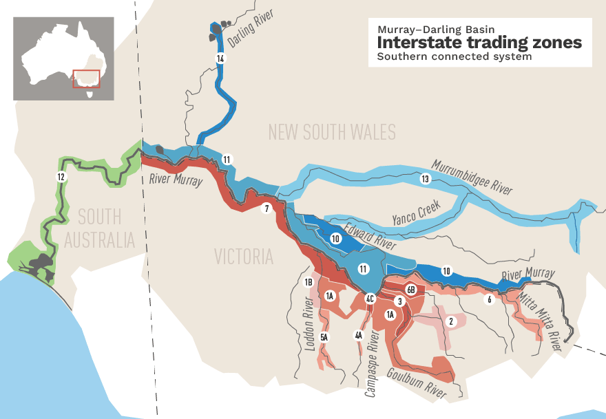
The map below shows the various trading zones in the southern Basin. The map details where water can move between 2 zones. This map is based on the Interstate water trading zones map as shown in the Schedule D protocol. The Allowable direction of water trades in the southern-connected Basin is a table of the permissible transfer between trading zones.
Greater Goulburn
(includes Lake Eildon to Goulburn Weir; Goulburn irrigation areas; except for Boort irrigation area)
Transfers may be made TO these trading zones::1B, 3, 6, 6B, 7, 10, 11, 12
Transfers may be made TO these trading zones as back trade only:: 2, 4A, 4C, 5A, 13,14
Transfers may be made FROM these trading zones:: 1B, 4A, 4C, 5A
Transfers may be made FROM these trading zones as back trade only:: 2, 3, 6, 6B, 7, 10, 11, 12, 13, 14
Boort
(includes the Boort irrigation area, west of the Loddon River)
Transfers may be made TO these trading zones::1A, 3, 6, 6B, 7, 10, 11, 12
Transfers may be made TO these trading zones as back trade only:: 2, 4A, 4C, 5A, 13,14
Transfers may be made FROM these trading zones:: 1A, 4A, 4C, 5A
Transfers may be made FROM these trading zones as back trade only:: 2, 3 6, 6B, 7,10, 11, 12, 13, 14
Broken
(includes Lake Nillahcootie, Broken River below Nillahcootie and upper Broken Creek (and Major Ck) from Broken River to Waggarandall Weir)
Transfers may be made TO these trading zones::3, 6, 7,10, 11, 12
Transfers may be made TO these trading zones as back trade only:: 1A, 1B, 4A, 4C, 5A, 6B, 13,14
Transfers may be made FROM these trading zones as back trade only:: 1A, 1B 3, 4A, 4C, 5A, 6, 6B, 7, 10, 11, 12, 13,14
Lower Goulburn
(includes Goulburn River below Goulburn Weir)
Transfers may be made TO these trading zones::6, 7, 10, 11, 12
Transfers may be made TO these trading zones as back trade only:: 1A, 1B, 2, 4A, 4C, 5A, 6B, 13, 14
Transfers may be made FROM these trading zones:: 1A, 1B, 2, 4A, 4C, 5A
Transfers may be made FROM these trading zones as back trade only:: 6, 6B, 7, 10, 11, 12, 13, 14
Campaspe
(includes Lake Eppalock to Waranga Western Channel; and Campaspe District)
Transfers may be made TO these trading zones::1A, 1B 3, 4C, 6, 6B, 7, 10, 11, 12
Transfers may be made TO these trading zones as back trade only:: 2, 5A, 13,14
Transfers may be made FROM these trading zones:: 4C
Transfers may be made FROM these trading zones as back trade only:: 1A, 1B, 2, 3, 5A, 6, 6B, 7, 10, 11, 12, 13, 14
Lower Campaspe
(includes lower Campaspe River from Waranga Western Channel to Murray River)
Transfers may be made TO these trading zones:1A, 1B 3, 4A, 6, 6B, 7, 10, 11, 12
Transfers may be made TO these trading zones as back trade only:: 2, 5A, 13, 14
Transfers may be made FROM these trading zones: 4A
Transfers may be made FROM these trading zones as back trade only: 1A, 1B, 2, 3, 5A, 6, 6B, 7, 10, 11, 12, 13, 14
Part Loddon
(includes Loddon River and Tullaroop Creek; from Cairn Curran and Tullaroop reservoirs to Loddon Weir; and Serpentine Creek system above Bears Lagoon)
Transfers may be made TO these trading zones: 1A, 1B 3, 6, 6B, 7, 10, 11, 12
Transfers may be made TO these trading zones as back trade only:: 2, 4A, 4C, 13, 14
Transfers may be made FROM these trading zones as back trade only: 1A, 1B, 2, 3, 4A, 4C, 6, 6B, 7, 10, 11, 12, 13, 14
Vic Murray above Barmah Choke
(includes River Murray from Lake Hume to Barmah Choke; Mitta Mitta River below Lake Dartmouth; and Murray Valley area)
Transfers may be made TO these trading zones: 10
Transfers may be made TO these trading zones as back trade only: 1A, 1B, 2, 3, 4A, 4C, 5A, 6B, 7, 11, 12, 13, 14
Transfers may be made FROM these trading zones: 1A, 1B, 2, 3, 4A, 4C, 5A, 6B, 7, 10, 11, 12, 13, 14
Lower Broken Creek
(includes Broken Creek downstream of Katamatite)
Transfers may be made TO these trading zones: 6, 7, 10,11,12
Transfers may be made TO these trading zones as back trade only: 1A, 1B, 2, 3, 4A, 4C, 5A, 13, 14
Transfers may be made FROM these trading zones: 1A, 1B, 4A, 4C, 5A
Transfers may be made FROM these trading zones as back trade only: 2, 3, 6, 7, 10, 11, 12, 13, 14
Vic Murray below Barmah Choke
(includes Torrumbarry area, Tresco, Nyah, Robinvale, Red Cliffs, Merbein and FMIT irrigation districts)
Transfers may be made TO these trading zones: 6, 10, 11, 12
Transfers may be made TO these trading zones as back trade only: 1A, 1B, 2, 3, 4A, 4C, 5A, 6B, 13, 14
Transfers may be made FROM these trading zones: 1A, 1B, 2, 3, 4A, 4C, 5A, 6B, 11,12, 13, 14
Transfers may be made FROM these trading zones as back trade only: 6, 10
NSW Murray above Barmah Choke
(includes River Murray from Lake Hume to Barmah Choke; and Murray Irrigation Ltd areas, including Wakool Irrigation District)
Transfers may be made TO these trading zones: 6
Transfers may be made TO these trading zones as back trade only: 1A, 1B, 2, 3, 4A, 4C, 5A, 6B, 7, 11, 12, 13, 14
Transfers may be made FROM these trading zones: 1A, 1B, 2, 3, 4A, 4C, 5A, 6, 7, 6B, 11, 12, 13, 14
NSW Murray below Barmah Choke
(includes River Murray from Barmah Choke to SA border (including the Edward / Wakool system and the Western Murray Irrigation District))
Transfers may be made TO these trading zones: 6, 7, 10, 12
Transfers may be made TO these trading zones as back trade only: 1A, 1B, 2, 3, 4A, 4C, 5A, 6B, 13, 14
Transfers may be made FROM these trading zones: 1A, 1B, 2, 3, 4A, 4C, 5A, 6B, 7, 12, 13, 14
Transfers may be made FROM these trading zones as back trade only: 6, 10
South Australian Murray
Transfers may be made TO these trading zones: 6, 7, 10, 11
Transfers may be made TO these trading zones as back trade only: 1A, 1B, 2, 3, 4A, 4C, 5A, 6B, 13, 14
Transfers may be made FROM these trading zones: 1A, 1B, 2, 3, 4A, 4C, 5A, 6B, 7, 11, 13, 14
Transfers may be made FROM these trading zones as back trade only: 6, 10
Murrumbidgee
(including Murrumbidgee Irrigation and Colleambally Irrigation areas; Murrumbidgee and Tumut below Burrinjuck and Blowering reservoirs (including Yanko, Colombo and Billabong Creek systems))
Transfers may be made TO these trading zones: 6, 7, 10, 11, 12
Transfers may be made TO these trading zones as back trade only: 1A, 1B, 2, 3, 4A, 4C, 5A, 6B, 14
Transfers may be made FROM these trading zones as back trade only: 1A, 1B, 2, 3, 4A, 4C, 5A, 6, 6B, 7, 10, 11, 12, 14
Lower Darling
(includes Menindee Lakes and the Darling River downstream of the Menindee Lakes)
Transfers may be made TO these trading zones: 6, 7, 10, 11, 12
Transfers may be made TO these trading zones as back trade only: 1A, 1B, 2, 3, 4A, 4C, 5A, 6B, 13
Transfers may be made FROM these trading zones as back trade only: 1A, 1B, 2, 3, 4A, 4C, 5A, 6, 6B, 7, 10, 11, 12,13
Victoria also has a more detailed trading zone map focusing on trading zones in northern Victoria. Additional zones shown on the Victorian trading zone map relate to trades restricted to Victorian valleys. View the Victorian trading zone map.
Trade of water entitlements and allocations can occur in both directions subject to the account limit rules, operational accounting rules and the trading rules set by the two state management plans.
The map below shows the areas that permit trade between New South Wales and Queensland. Trade can occur to and from the Macintyre Brook, Queensland Border Rivers trading areas (shaded green on the map), and the New South Wales Border Rivers water management area (shaded blue on the map). This area includes the unregulated Barwon, Macintyre and Severn Rivers.
This agreement is not the responsibility of the Murray–Darling Basin Authority (MDBA). For more information on the allowable trade between these states, contact the New South Wales or Queensland state governments.