In this update:
- catchment conditions
- forecast rainfall and inflows
- water releases
- planned management for the coming week
Catchment conditions
For the week of 23 to 29 August the highest rainfall as shown in the below image fell in the upper Murray at the start of the week. This was followed by the rainfall event that occurred on 29 to 30 August, which saw widespread falls of 25 to 50 mm in the upper Murray.
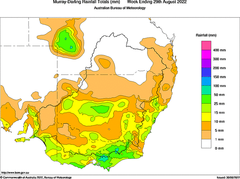
Soil moisture levels have remained high in the Upper Murray catchment throughout August and continue to be slightly above average for this time of year. The average modelled soil moisture value for the upper Murray catchment is sitting at 68% with very little change over the past 3 weeks.
Forecast rainfall and inflows

Most of forecast rain for the upper Murray area is associated with the end of the recent event. There is likely to be a break in the rainfall for the remainder of this week, and potential for another rainfall system from mid next week.
The 7-day forecast map is automatically generated and subject to change daily when the models are run.
The Bureau of Meterology forecasts is the best source of information to stay up to date with more detailed forecast rainfall.
Rainfall from 29 to 30 August increased inflows in the Kiewa River at Bandiana in Victoria and River Murray at Biggara in Victoria. River levels remain elevated, with a slow decline in levels expected over the coming week.
The outlook for the next 2 weeks indicates a high chance of above-median rainfall for this time of the year. The outlook for spring shows a similar picture with high change of above-median rainfall.
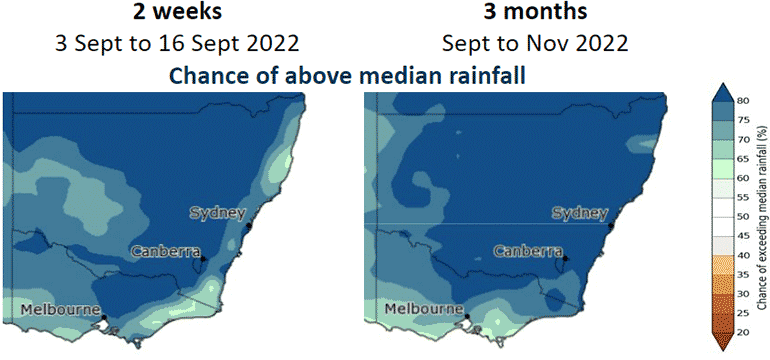
Currently there is an La Niña alert – the chance of La Niña forming in the coming months is at least 70%. This is around 3 times the normal likelihood of a La Niña event forming. La Niña conditions increase the chance of above average spring and summer rainfall in northern and eastern Australia.
In addition, the negative Indian Ocean Dipole (IOD) event continues. There's consistency across all the models indicating that negative IOD conditions are likely to continue into late spring. A negative IOD event is typically associated with above average spring rainfall for much of Australia.
Hume and Dartmouth Dam operations this week

Flood operations are being conducted at both dams.
Useful airspace volumes are currently available in each dam however the focus remains on generating more airspace to assist in mitigating future events, while minimising the impacts downstream. The airspace in Hume Dam has remained relatively stable in recent weeks and forecast drier conditions in the coming week will allow more space to be generated. At Dartmouth Dam however airspace continues to be lost with limited ability to regain it, and future inflow events could see water flowing over the spillway.
Releases from the Dartmouth Dam are targeting flows in the Mitta Mitta River which are just below channel capacity at Tallandoon. Currently it is unlikely flows will exceed channel capacity, but this cannot be ruled out.
Releases from Hume Dam into the River Murray were reduced to 33,000 megalitres per day on 29 August in response to the rainfall downstream. When combined with inflows from the Kiewa River it is expected flows will occur at Albury below the minor flood level. Once the inflow from the Kiewa River recedes, options to increase releases to generate additional airspace will begin.
Are you flood ready?
If you live, work or holiday on a floodplain, be prepared
Develop your personalised flood emergency plan for your home and property
www.ses.nsw.gov.au
www.ses.vic.gov.au/plan-and-stay-safe
All residents can sign up for the Early Warning Network to be notified about dam release activities during periods of flooding or high releases
www.waternsw.com.au/supply/ewn
Check the BoM website to receive the latest weather and flood information and warnings in your area
www.bom.gov.au/australia/flood
www.bom.gov.au/australia/warnings