This update provides an overview on how the Murray–Darling Basin Authority is managing Hume Dam and Dartmouth Dam during the current high flows.
The regular update includes:
- catchment conditions
- forecast rainfall and inflows
- water releases
- planned management for the coming week.
Catchment conditions
For the week of 20 to 26 September the rainfall for Victoria and southern New South Wales was largely above average. Soil moisture levels continue to be above average for this time of year with around a quarter of the catchment still over 90% saturated.
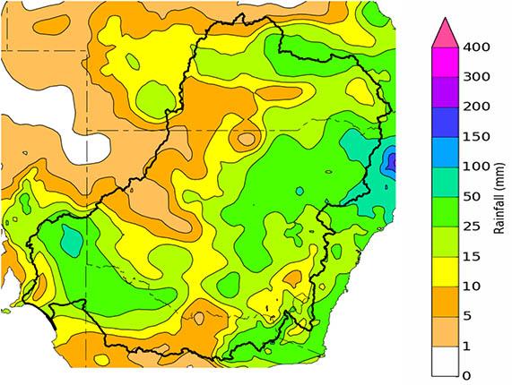
Forecast rainfall and inflows
The Bureau of Meteorology is expecting rainfall totals to 3 October to be in the range of 15 – 25mm for parts of the Upper Murray region with some areas forecast to receive up to 50mm.
The 7-day forecast map is automatically generated and subject to change daily when the models are run.
The Bureau of Meteorology is the best source of information to stay up-to-date with more detailed forecast rainfall and flood information.
The outlook for the next 2 weeks shows a high chance of above-median rainfall. The outlook for the next 3 months shows a similar picture with a high chance of above-median rainfall.
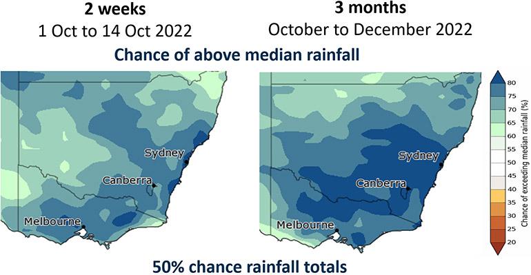
The status of the Bureau of Meteorology’s El Niño–Southern Oscillation Outlook has been raised to La Niña. The Bureau suggests this La Niña event may peak during spring and return to neutral conditions early in 2023. La Niña events increase the chances of above-average rainfall during spring and summer for northern and eastern Australia.
In addition, the negative Indian Ocean Dipole (IOD) event is likely to continue into late spring. A negative IOD event is typically associated with above average spring rainfall for much of Australia.
Snapshot: Dartmouth and Hume

Dartmouth Dam and Hume Dam this week
Flood operations are being conducted at both dams.
Dartmouth Dam is flowing over the spillway. The flow in the Mitta Mitta River downstream will be dependent on the spillway flow plus inflows from tributaries downstream of Dartmouth Dam.
It is unlikely that channel capacity in the river at Tallandon will be exceeded in coming days, but it cannot be ruled out.
Releases from Hume Dam were increased in ahead of a potential significant rain event. The MDBA will monitor the inflow it generates, before deciding whether releases will be adjusted in either direction. Forecasts indicate a period of dry weather following this event which will allow airspace to be regained.
The MDBA does not provide flow forecasts during periods of flooding. Please refer to the Bureau of Meteorology.
Are you flood ready?
If you live, work or holiday on a floodplain, be prepared
Develop your personalised flood emergency plan for your home and property
www.ses.nsw.gov.au
www.ses.vic.gov.au/plan-and-stay-safe
All residents can sign up for the Early Warning Network to be notified about Hume Dam release activities during periods of flooding or high releases
www.waternsw.com.au/supply/ewn
Check the BoM website to receive the latest weather and flood information and warnings in your area
www.bom.gov.au/australia/flood
www.bom.gov.au/australia/warnings