The regular update includes:
- catchment conditions
- forecast rainfall and inflows
- water releases
- planned management for the coming week.
Catchment conditions
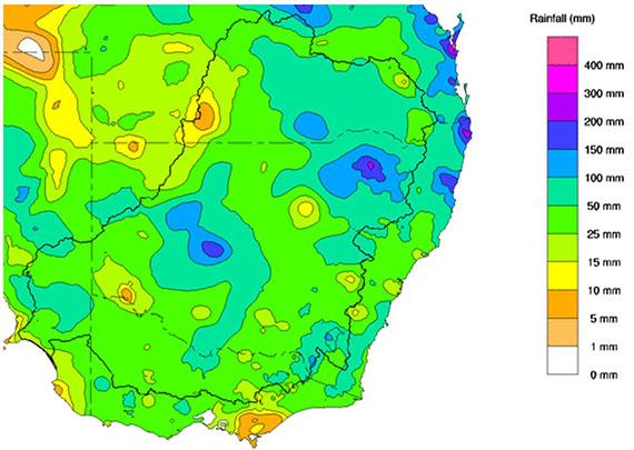
For the week of 18 to 24 October the rainfall across the Murray–Darling Basin was largely above average with most areas receiving 50 to 100mm. Soil moisture levels for the upper Murray show very little change since last week, currently sitting at 73%, which is above average for this time of year.
Forecast rainfall and inflows
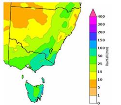
The Bureau of Meteorology is expecting rainfall totals to 31 October 2022 to be in the range of
50 – 100 mm across much of the southern Murray–Darling Basin, including significant falls in Victoria.
The 7-day forecast map is automatically generated and subject to change daily when the models are run.
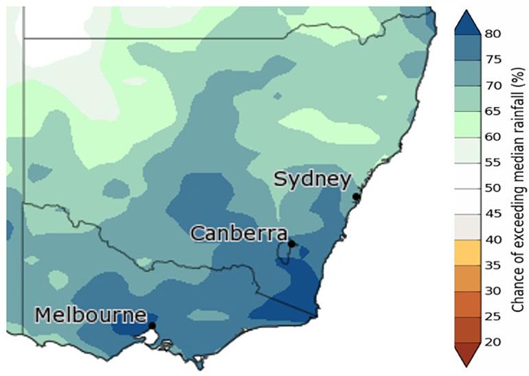
The outlook for the next 3 months shows a similar picture with a high chance of above-median rainfall.
The Bureau of Meteorology is the best source of information to stay up-to-date with more detailed forecast rainfall and flood information.
The status of the Bureau of Meteorology’s El Niño–Southern Oscillation Outlook is currently La Niña. The Bureau suggests this La Niña event may return to neutral conditions early in 2023. La Niña events increase the chances of above-average rainfall during spring and summer for northern and eastern Australia.
In addition, the negative Indian Ocean Dipole (IOD) event is likely to continue into late spring before rapidly decaying. collapse at the end of spring. A negative IOD event is typically associated with above average spring rainfall for much of Australia.
Snapshot: Dartmouth and Hume
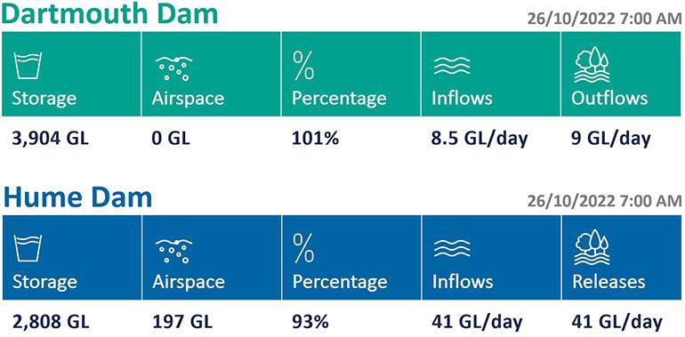
Dartmouth Dam and Hume Dam this week
The MDBA’s priority is keeping the Hume and Dartmouth Dams safe, capturing and storing water, and where we can, mitigating floods.
Flood operations are being conducted at both dams.
Rain is forecast over the upper Murray catchments for the coming days. Additional airspace at Hume Dam was created ahead of the recent rainfall to capture the peak inflows and help reduce releases from the dam.
Given the uncertainty surrounding the amount of rainfall that will eventuate, this airspace will provide flexibility in how the MDBA can respond. Releases in coming days are likely to remain similar to where they are now, but if more or less rain is received than expected adjustments may be made.
Downstream of Dartmouth Dam, the flow in the Mitta Mitta River will depend on the volume flowing over the dam spillway as well as inflows from downstream tributaries. River channel capacity at Tallandoon has been exceeded, however the level is well below minor flood.
The situation is constantly evolving, and rivers can rise very quickly.
The MDBA does not provide flow forecasts during periods of flooding. For information on river heights please refer to the Bureau of Meteorology.
Are you flood ready?
If you live, work or holiday on a floodplain, be prepared.
Develop your personalised flood emergency plan for your home and property
www.ses.nsw.gov.au
www.ses.vic.gov.au/plan-and-stay-safe
All residents can sign up for the Early Warning Network to be notified about Hume Dam release activities during periods of flooding or high releases
www.waternsw.com.au/supply/ewn
Check the BoM website to receive the latest weather and flood information and warnings in your area
www.bom.gov.au/australia/flood
www.bom.gov.au/australia/warnings