The regular update includes:
- catchment conditions
- forecast rainfall and inflows
- water releases
- planned management for the coming week.
Catchment conditions
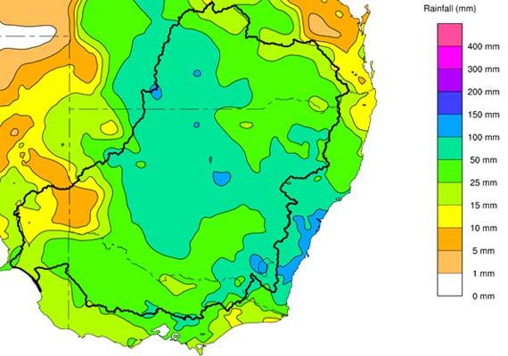
For the week of 4 to 10 October the rainfall for Victoria and southern New South Wales remained largely above average with most areas receiving between 50 – 100mm. Soil moisture levels for the upper Murray are slightly higher than last week at 72% and continue to remain above average for this time of year.
Forecast rainfall and inflows
The Bureau of Meteorology is expecting rainfall totals to 17 October to be in the range of
50 – 100mm across much of the southern Murray–Darling Basin, including significant falls in Victoria.
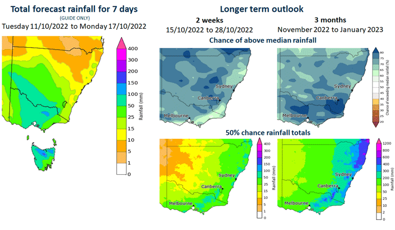
The 7-day forecast map is automatically generated and subject to change daily when the models are run.
The Bureau of Meteorology is the best source of information to stay up-to-date with more detailed forecast rainfall and flood information.
The outlook for the next 2 weeks shows a high chance of above-median rainfall. The outlook for the next 3 months shows a similar picture with a high chance of above-median rainfall.
The status of the Bureau of Meteorology’s El Niño–Southern Oscillation Outlook has been raised to La Niña. The Bureau suggests this La Niña event may peak during spring and return to neutral conditions early in 2023. La Niña events increase the chances of above-average rainfall during spring and summer for northern and eastern Australia.
In addition, the negative Indian Ocean Dipole (IOD) event is likely to continue into late spring. A negative IOD event is typically associated with above average spring rainfall for much of Australia.
Snapshot: Dartmouth and Hume Dams
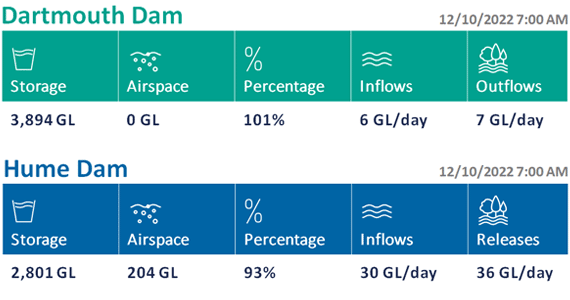
Dartmouth Dam and Hume Dam this week
Flood operations are being conducted at both dams.
The current forecasts indicate that the highest rainfall totals will occur in catchments downstream of Hume Dam. Reasonable rainfall is expected in the Hume catchment, but the Bureau is not forecasting totals as high as those expected downstream of the dam.
With the airspace currently available at Hume Dam, the storage is expected to handle the forecast inflows without requiring major adjustments to releases. However, if inflows are significantly higher than forecast, releases will need to quickly be increased.
Depending on inflows from the Kiewa River the minor flood level at Albury may be exceeded.
Water is flowing over the spillway at Dartmouth Dam. The flow in the Mitta Mitta River will be dependent on the spillway flow plus inflows from tributaries such as Snowy Creek downstream of the dam.
It is likely that channel capacity at Tallandoon will be exceeded in coming days. It is possible Tallandoon may reach minor flood level if significant amounts of rain falls, especially in the Snowy Creek catchment.
The MDBA does not provide flow forecasts during periods of flooding. For information on river heights please refer to the Bureau of Meteorology.
Are you flood ready?
If you live, work or holiday on a floodplain, be prepared
Develop your personalised flood emergency plan for your home and property
www.ses.nsw.gov.au
www.ses.vic.gov.au/plan-and-stay-safe
All residents can sign up for the Early Warning Network to be notified about Hume Dam release activities during periods of flooding or high releases
www.waternsw.com.au/supply/ewn
Check the BoM website to receive the latest weather and flood information and warnings in your area
www.bom.gov.au/australia/flood
www.bom.gov.au/australia/warnings