The regular update includes:
- catchment conditions
- forecast rainfall and inflows
- water releases
- planned management for the coming week.
Catchment conditions
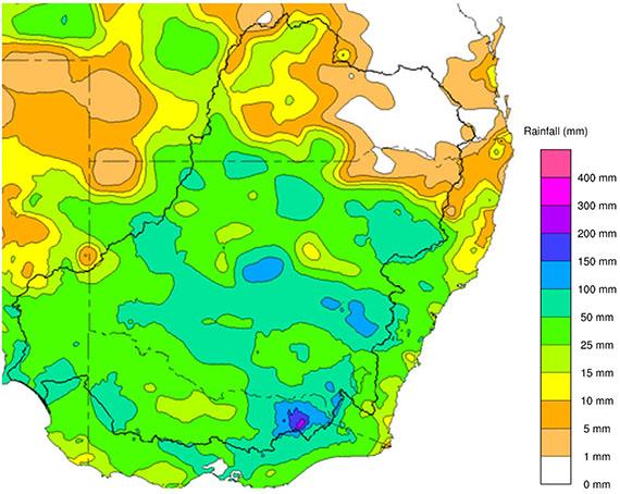
For the week of 9 to 15 November the rainfall across the Murray–Darling Basin was largely above average with heavy rainfall in the Mitta Mitta and Kiewa Rivers, which received over 150 mm during this period. Most of this accumulated in the 48 hours to 9am Monday morning. Soil moisture levels for the Upper Murray have eased slightly since last week to 63%, it remains in the top 10% of historical values for this time of year.
Forecast rainfall and inflows
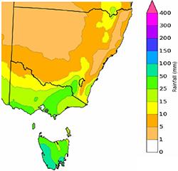
The Bureau of Meteorology is expecting rainfall totals to 21 November 2022 to be in the range of 20 to 50mm across parts of the Upper Murray catchment. Models currently show that most of this rain is expected from the weekend, particularly Sunday into Monday as a low passes south of Tasmania.
The 7-day forecast map is automatically generated and subject to change daily when the models are run./p>
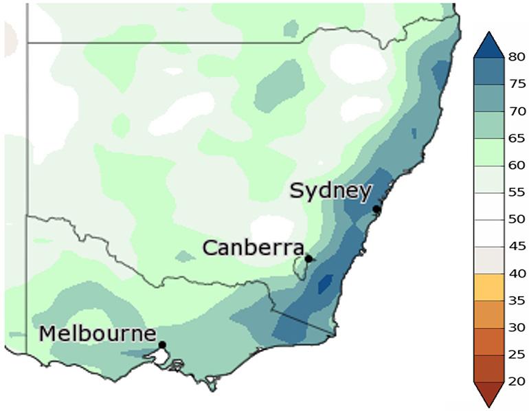
The outlook for the next 3 months from December to February indicates a high chance of above-median rainfall including a 65% to 75% chance for most of the Upper Murray catchment. This is not as strong a signal as we've been seeing in the previous outlooks from the Bureau of Meteorology.
The Bureau of Meteorology is the best source of information to stay up-to-date with forecast rainfall and flood information.
The status of the Bureau of Meteorology’s El Niño–Southern Oscillation Outlook is currently La Niña. The Bureau suggests this La Niña event may return to neutral conditions early in 2023. La Niña events increase the chances of above-average rainfall during spring and summer for northern and eastern Australia.
In addition, the negative Indian Ocean Dipole (IOD) event is likely to continue through late spring. A negative IOD event is typically associated with above average spring rainfall for much of Australia.
Snapshot: Dartmouth and Hume
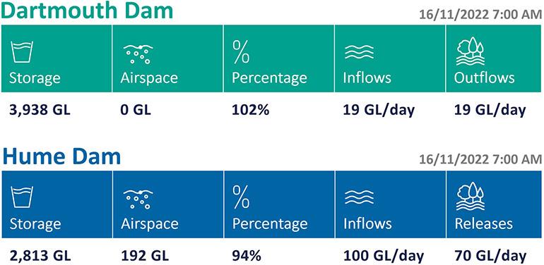
Dartmouth Dam and Hume Dam this week
Flood operations are being conducted at both dams.
With further rain forecast for the weekend the MDBA is looking to regain airspace at Hume Dam ahead of the event, however the MDBA is mindful of the impact high river levels are having downstream.
Releases may gradually increase as inflows from the Kiewa River recede, so the river level downstream does not increase. The timing and volume of increases will depend on how the forecast rain evolves over coming days. If the forecast weakens, increases may be delayed allowing the river level to drop, but if the rainfall forecast strengthens, releases may need to increase more quickly to ensure we regain airspace ahead of the event.
Flows are continuing over the spillway at Dartmouth Dam. The flow in the Mitta Mitta River will be dependent on the volume flowing over the spillway plus inflows from tributaries downstream of the dam.
The situation is constantly evolving, and rivers can rise very quickly.
The MDBA does not provide flow forecasts during periods of flooding. For this information, please refer to the Bureau of Meteorology.
Are you flood ready?
If you live, work or holiday on a floodplain, be prepared
Develop your personalised flood emergency plan for your home and property
www.ses.nsw.gov.au
www.ses.vic.gov.au/plan-and-stay-safe
All residents can sign up for the Early Warning Network to be notified about Hume Dam release activities during periods of flooding or high releases
www.waternsw.com.au/supply/ewn
Check the BoM website to receive the latest weather and flood information and warnings in your area
www.bom.gov.au/australia/flood
www.bom.gov.au/australia/warnings